- Slug: BC-CNS-Climate Study. 1,285 words.
- 2 photos and captions below.
- 2 graphics and captions below.
- SoundClound clip here.
By LUKE RUNYON
KUNC
GREELEY, Colo. – The effects of climate change are not far off challenges for future generations. They are existential problems for everyone alive today.
That’s one big takeaway from the U.S. federal government’s latest roundup of climate science, the National Climate Assessment, now in its fourth iteration.
Released the day after Thanksgiving, the report is unequivocal. In short, declarative sentences that are heavily footnoted, it urgently tells readers that climate change is happening, it’s human-caused and it could make life in the Western U.S. increasingly difficult.
The report is a product of the U.S. Global Change Research Program, an amalgam of 13 federal agencies. Its publication is required by law.
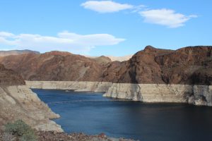
In a chapter dedicated to climate change effects in the Southwest, climate scientists said “with very high confidence” that high temperatures are reducing the water content of mountain snowpack and the flows of rivers and streams that depend on snowmelt. The chapter’s landing page features a photo of low water levels at the nation’s largest reservoir, Lake Mead outside Las Vegas, a nearly perfect symbol of the region’s ongoing water challenges.
Mead is fed by the Colorado River, whose watershed provides drinking and irrigation water for 40 million people across seven U.S. states and two states in Mexico. In addition to sapping the nation’s largest desert reservoirs, the report said, the changing climate also is leading to more intense droughts, increasing the risk of severe floods, weakening key infrastructure projects and depleting groundwater.
Without new ways to manage water and cut greenhouse gas emissions, the report said, existing gaps between water supplies and demands in the Southwest will only continue to grow.
Much of the report confirms and reconfirms what scientists already know. Here are the biggest takeaways for the Southwest, defined as California, Nevada, Arizona, New Mexico, Colorado and Utah.
‘Water security in the United States is increasingly in jeopardy’
That sentence greets readers of third chapter, dedicated to exploring how climate change will stress U.S. water infrastructure.
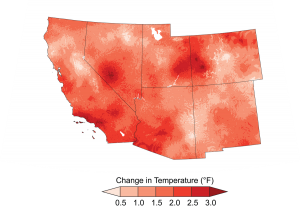
In a scenario where greenhouse gas emissions increase, the report said, the entire region could see its average annual temperature rise an additional 8.6 degrees by 2100. Southern parts of the region, which include Phoenix, Tucson and San Diego, could see their summers extend well into the spring and fall, with 45 more days each year where temperatures climb past 90 degrees.
That warming means areas of the Southwest already at risk for long term drought are seeing the risk increase for more intense, prolonged droughts in the future. Droughts can materialize from both a lack of precipitation and a rise in temperature, and then be exacerbated by human activities. Each drought is the product of particular circumstances, the report noted, and can be intensified by dwindling groundwater, which in some regions acts as a buffer against scarce surface-water supplies.
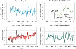
Other studies have shown that rising temperatures in the Colorado River Basin are depleting river flows and increasing evaporation in streams and reservoirs. From 2000 to 2014, the driest period of record on the Colorado, climate change tipped the scales toward higher temperatures, resulting in streamflow reductions of 17 to 50 percent.
Drought can occur naturally, the report noted, but the increase in temperature from climate change can amplify the effects, causing a more typical drought to last longer and cause more damage. This is true for the recent drought in California and the ongoing Colorado River drought.
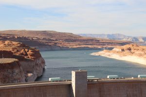
Underlining the fact that some climate change effects already are being felt, the Colorado River system hit a new low point earlier this year when its key reservoirs dropped to levels not seen in decades.
Shrinking snowpack likely to continue
Southern Rocky Mountain snowpack in Colorado, Wyoming and Utah supplies the vast majority of river flows in the Colorado River watershed. And it’s becoming increasingly scarce.
If greenhouse gas emissions continue unabated, climate models project significant reductions in mountain snowpack – and not simply because of decreased precipitation. Higher temperatures, especially at lower elevations, result in precipitation falling as rain, which holds less water than snow.
The warming also can shorten snowfall seasons. In the most extreme scenario modeled in the report, portions of California’s mountains that currently receive snow “would begin to receive more precipitation as rain and then only rain by 2050.”
Lower elevations in the southern Rockies that currently receive snow could begin to see their accumulations deteriorate, the report said. Even under a high emissions scenario, it’s unlikely snow would be completely eliminated at high elevations where lower temperatures are projected to remain.
To make up for reduced streamflows, the Southwest would need a large increase in precipitation, something the report doesn’t predict.
Snow droughts, like the dry winter of 2017-18, can be caused by a lack of precipitation, temperatures that are too high for snow to form or a combination of the two, the report said.
We can adapt. But can we do it fast enough?
Some parts of the Southwest already are showing resilience in the face of a warming climate, the report said.
Many of the region’s biggest cities, including Las Vegas, Denver, Los Angeles and Phoenix, have cut their per capita water use for the past three decades at the same time population has grown. Much of that savings is due to conservation measures, such as lawn-buyback programs, water efficiency upgrades in homes and investments in water reuse technology. But urban conservation alone can’t solve the region’s water woes.
The near certainty of severe water shortages adds pressure to water managers. The report challenged those officials to create more flexible methods of managing existing water supplies.
Figuring out who should use less water to help the region adapt to a drier, warmer future won’t be easy. Water use reductions across the Southwest are driving the creation of Drought Contingency Plans currently being negotiated by the seven U.S. states that rely on the Colorado River. Even those negotiators say the plans are a stopgap solution to prevent the river’s largest reservoirs from crashing, not a long term response to warming and drying trends.
The report also throws a wet blanket on some of the sexier solutions to Southwestern water scarcity. Desalination of ocean water often is trotted out as a possible savior for cities and farms. But current desalination technology “creates greenhouse gas emissions and its capital costs are high.”
Still, the report’s authors praised Colorado River managers for creating some flexibilities in the system. In 2007, amid record dry conditions, Arizona, California and Nevada signed an agreement to allow users to forgo water deliveries and store supplies in Lake Mead. A binational agreement in 2014 between the U.S. and Mexico resulted in an experimental flow of water in the river’s desiccated delta. A 2017 agreement brought Mexican water leaders to the table and resulted in promises to share in future water shortages should reservoirs continue to drop.
The severity of water shortages in the Southwest is largely up to us, as the report noted in its section on how confident climate scientists are in their findings: “The actual frequency and duration of water supply disruptions will depend on the preparation of water resource managers with drought and flood plans, the flexibility of water resource managers to implement or change those plans in response to altered circumstances, the availability of funding to make infrastructure more resilient, and the magnitude and frequency of climate extremes.”
This story is part of a project covering the Colorado River, produced by KUNC and supported through a Walton Family Foundation grant. KUNC is solely responsible for its editorial content.
This story is part of Elemental: Covering Sustainability, a multimedia collaboration between Cronkite News, Arizona PBS, KJZZ, KPCC, Rocky Mountain PBS and PBS SoCal.
Connect with us on Facebook.
For more stories from Cronkite News, visit cronkitenews.azpbs.org.


