- Slug: BC-CNS-Google Justice,540
- Photos available (thumbnails, captions below)
By JAMIE COCHRAN
Cronkite News
WASHINGTON – GPS does many things, but one thing it does not do is lie, a federal court ruled Thursday.
A three-judge panel of the 9th U.S. Circuit Court of Appeals said a Google Earth map generated from GPS coordinates of an arrest was not hearsay and could be admitted in the trial of a man accused of entering the country illegally.
Paciano Lizarraga-Tirado argued that he was still in Mexico when Border Patrol agents arrested him in 2003, and he tried to have the GPS map kept out of his trial.
The appeals court disagreed, comparing a GPS-generated map to a photograph, which it has ruled is not hearsay.
“A photograph merely depicts a scene as it existed at a particular time. The same is true of a Google Earth satellite image,” wrote Circuit Judge Alex Kozinski in the opinion.
“Because a satellite image, like a photograph, makes no assertion, it isn’t hearsay,” he wrote.
Roger Sigal, the attorney for Lizarraga-Tirado, declined to comment on the ruling. Calls seeking comment from the U.S. Attorney’s Office were not immediately returned Thursday.
The case started on Jan. 17, 2003, when Lizarraga-Tirado was arrested south of Sells by two Border Patrol agents, one of whom had a handheld GPS device at the time, and charged with illegal re-entry into the U.S.
Lizarraga-Tirado testified that he was still in Mexico, awaiting instructions from a smuggler, when he was arrested. He said it was a dark night in a remote location and that the agents must have accidentally crossed the border in the night.
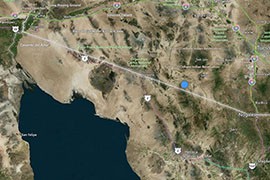
The agents testified that they were familiar with the area and were still in the U.S. – and backed it up with a map and tack, generated with the GPS coordinates, that pinpointed the arrest on the Tohono O’odham reservation, well north of the border.
Lizarraga-Tirado’s attorney objected to the admission of the satellite image, added location tack and coordinates as hearsay, but was overruled.
The appeals court noted that while the border patrol agents were questioned on whether they entered the coordinates correctly to generate the map, the defense did not challenge “the origin of the satellite image or the tack.”
If the agents had manually labeled and placed the tack on the map then it’s “classic hearsay,” Kozinksi wrote, just like “drawing an X on a paper map and labeling it ‘hidden treasure.’”
But the court said the the tack was “automatically generated by the Google Earth Program” and it isn’t hearsay, since the computer itself does all of the work.
“The program analyzes the GPS coordinates and, without any human intervention, places a labeled tack on the satellite image,” said the opinion, which noted the the judges themselves had entered the coordinates and got the same map as the one at trial.
The opinion noted that GPS evidence could be challenged on the grounds that the machine was malfunctioning, it produced inconsistent results or had been tampered with. Such an authentication objection could be met by calling a programmer or an expert who works with GPS programs to testify, or other means.
But Lizarraga-Tirado did not raise an authentication objection at trial or an appeal. He only raised a hearsay objection, which was “properly overruled.”
^__=
Web Links:
_ Opinion: http://cdn.ca9.uscourts.gov/datastore/opinions/2015/06/18/13-10530.pdf
^__=
A GPS-generated map, like this one, shows were Paciano Lizarraga-Tirado was arrested by Border Patrol agents, who marked the coordinates as 31.75846, -11.14192. A court said such maps are not hearsay evidence in a trial. (Photo by Cronkite News/Bing Maps)
